



Cliffs that drop sheer into the sea, fishing harbours, estuaries that reach far inland, beaches that come and go with the tide and the grand houses of returning emigrants gazing out to sea. The north coast of Spain has nothing to do with the sun-and-beach-bar postcard: here the Cantabrian Sea sets the pace, the green runs right down to the sand and, when the fog rolls in, the lighthouses and hermitages perched on the rocks look like something out of a legend.
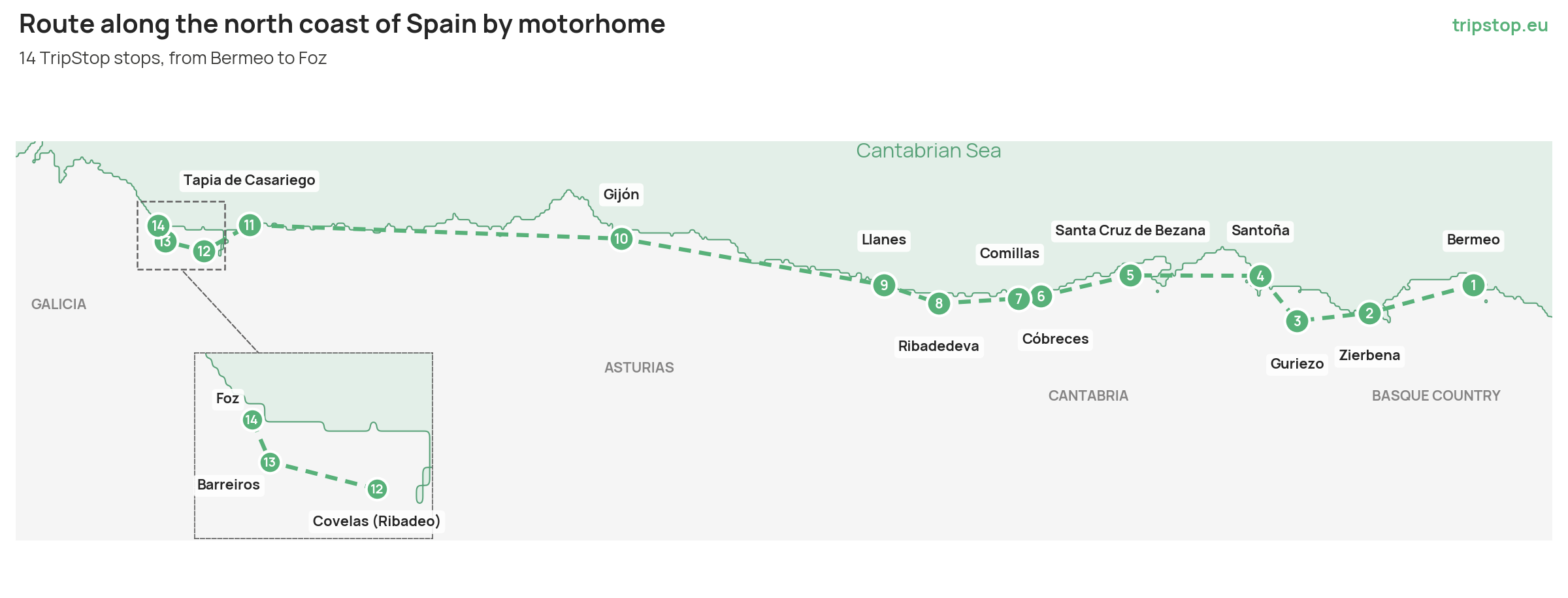
This motorhome route through northern Spain follows the Cantabrian coast from east to west in 14 TripStop stops: it starts in Bermeo, in Biscay, crosses Cantabria and Asturias and ends in Foz, in Galicia's A Mariña Lucense. Each number on the map is a stop, and at each one there's a camper spot where you can spend the night.
In this guide you'll find the 14 numbered stops, what to see and do at each one, the distances between stages, practical tips for planning the trip and the TripStop camper spot where you can spend the night at every stop.
How to plan your motorhome route through northern Spain
Linking the 14 stops adds up to around 600 km, almost always just a few minutes from the Cantabrian motorway (A-8). Driving stages are short and leave plenty of time to get out and walk. The longest stretch links Gijón and Tapia de Casariego; the shortest, between Cóbreces and Comillas, is barely 10 km along the CA-131, the coastal road that Cantabria's tourist board recommends for exploring this part of the region.
There's no official length for this route. Our suggestion: between 12 and 16 days, with one night per stop and two in Santoña, Gijón and Ribadeo. If you can choose, spring and late summer are quieter than July and August. Whenever you travel, book the two visits we mark as must-sees well in advance, as both require a ticket or permit.
A tip for the whole route: leave the motorhome at the camper spot and walk into the old towns of Bermeo, Comillas, Llanes or the Cimavilla quarter in Gijón. Their narrow streets are made for strolling, not for a large vehicle.
TIP: KEEP A TIDE TABLE TO HAND
On this coast the sea changes the landscape twice a day. At low tide you can walk out to the island of El Castro, at Covachos, or to Pena de Altar, in Barreiros, and it's the best time to walk beneath the arches of As Catedrais. At high tide, those same beaches shrink or disappear. Before planning a walk along the shore, check when the water goes out.
Basque Country: from the port of Bermeo to La Arena beach
Must-see · San Juan de Gaztelugatxe
1. Bermeo
The route sets off from one of Biscay's major fishing ports, at the foot of Mount Sollube and within the Urdaibai Biosphere Reserve. Bermeo is best understood from the water: boats leave the Old Port to sail around San Juan de Gaztelugatxe and see it from the sea, or head out towards the island of Izaro.
Gaztelugatxe belongs to the municipality and lies about 8 km from the centre. It's one of the most visited spots in Biscay, so you need to book a ticket in advance (free, on the Biscay Provincial Council website ↗). In summer, Bermeo's tourist office runs a bus and guided tours that include booking the ticket for you.
Back in town, the Fisherman's Museum occupies the Ercilla tower, a national monument, and is one of the few museums in the world devoted solely to the life and work of fishermen (Tue-Sat 10.00-14.00 and 16.00-19.00, Sun 10.00-14.00). A short walk away are the Gothic church of Santa Eufemia and the San Juan Gate. You'll find more ideas in our guide to travelling to Bermeo by motorhome.
On the road » About 50 km to Zierbena on the BI-631 and the A-8, through the Bilbao area.
2. Zierbena
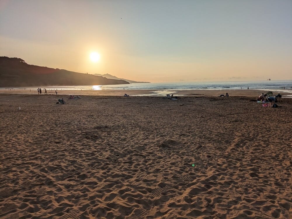
Zierbena is home to the last Biscay beach before Cantabria: La Arena, which it shares with Muskiz. Almost a thousand metres of sand (966 m) with three different waves, it's a favourite with surfers from the Left Bank and a place where beginners take lessons.
To stretch your legs, climb Punta Lucero (307 m) on the path marked with green arrows from the La Cuesta neighbourhood: at the top there are bunkers, tunnels and cannons, with the beach at your feet. If you'd rather cycle, Biscay's longest bike path runs from the beach all the way to Portugalete (11 km).
In the afternoon, the harbour invites you to linger over a long meal: it still has fishing boats and restaurants serving chargrilled fish. We tell you all about it in travelling to Zierbena by motorhome.
On the road » About 30 km on the A-8 to the Guriezo exit, now in Cantabria.
Cantabria: valleys, lighthouses and Gaudí's Capricho
3. Guriezo
The first stop in Cantabria and the only inland one: a green valley in the Asón-Agüera district, spread across small hamlets, a stone's throw from the A-8 and the sea. It's the place to change pace, with paths for walking or cycling that start right from the camper spot.
If you're here for the Magdalena festivities, the main day is 22 July. In May, the San Isidro fair brings together a livestock show and rural sports.
On the road » About 30 km to Santoña on the A-8 and the CA-241.
4. Santoña
Santoña reveals itself as you climb Mount Buciero, a limestone massif that drops into the sea among Napoleonic forts, lighthouses and cliffs. Its network of waymarked trails (five routes on the mountain, plus one through the marshes) leads to viewpoints over the bay and Berria beach. It's the best stop on the route to lace up your boots.
The most famous trail leads down to the Caballo lighthouse (1863) via 763 steps carved into the rock by inmates from the El Dueso prison. Right now the town council's website warns of a temporary closure of access, so check before you go. The Pescador lighthouse, rebuilt after a cyclone in 1915, is also on Mount Buciero, at the foot of a cliff, although you can't go inside.
On the road » About 45 km on the A-8, skirting Santander, to Santa Cruz de Bezana.
5. Santa Cruz de Bezana
Here the coast breaks into cliffs that hide small beaches, within the Costa Quebrada UNESCO Global Geopark. The easiest to reach is San Juan de la Canal (690 m, Blue Flag), with parking next to the CA-231. From Soto de la Marina, a 1,200 m coastal path runs past five viewpoints and along a wooden boardwalk over the inlet.
The real show is at Covachos: at low tide, a tongue of sand joins the beach to the island of El Castro; at high tide, the islet is cut off again (naturist beach, reached by steps). If you're travelling with a dog, Jortín cove, five minutes from San Juan de la Canal, allows dogs. And on the night of San Juan, the beach bonfire draws thousands of people on the shortest night of the year.
On the road » About 35 km on the A-67 and the CA-131 to Cóbreces.
6. Cóbreces
Cóbreces, in Alfoz de Lloredo, is the gateway to Comillas. Its skyline is defined by the Cistercian abbey of Viaceli (1908), where you can buy the Trapa cheese made by its monks. Among 18th-century mountain manor houses, a road runs 1 km down to Luaña beach, with fine golden sand.
On the road » About 10 km on the CA-131 to Comillas: the shortest stretch of the route and one of the prettiest.
7. Comillas
Comillas is the great cultural stop in Cantabria. In the late 19th century, the first Marquis of Comillas, Antonio López, brought in Catalan architects such as Gaudí, Martorell and Domènech i Montaner, and the town added eleven Modernist works to its traditional manor houses.
Start with El Capricho de Gaudí (1883), an oriental-style villa clad in sunflower tiles and one of the architect's few works outside Catalonia (Jul-Sep 10.30-21.00; about 30 min). Continue with the Sobrellano Palace and its chapel-pantheon, the Pontifical University and the Tres Caños fountain (1899). Finish at the cemetery, with Llimona's angel standing over the ruins of a Gothic chapel; Cantabria's tourist board ranks it among the most visited in Spain.
If you love towns with this kind of charm, you'll find more in the most beautiful villages in Spain by motorhome.
On the road » About 35 km on the CA-131 and the A-8 to Ribadedeva, now in Asturias.
Asturias: indianos, blowholes and seaside towns
8. Ribadedeva
The eastern gateway to Asturias is a history lesson in just a few kilometres. According to Asturias's tourist board, Colombres, its main town, has the region's finest collection of indiano architecture, built by emigrants who made their fortune in the Americas. In one of these mansions, Quinta Guadalupe, you'll find the Indianos Archive – Emigration Museum, which tells the story of those who left for the Americas (check opening times on its website).
On the road » About 25 km on the A-8 to Llanes.
9. Llanes
Asturias's tourist board counts it among the prettiest seaside towns in the north, and one stroll is enough to see why. The old town has a medieval tower, a casino and palaces; at the harbour, Agustín Ibarrola painted the Cubes of Memory on the breakwater; and above it all, the Paseo de San Pedro overlooks the town, Sablón beach and the Sierra del Cuera.
We cover everything, including where to park during the day and where to sleep, in our guide to travelling to Llanes by motorhome.
On the road » About 95 km on the A-8 to Gijón.
10. Gijón
Gijón is the great seafaring city on the route, the stop where you swap trails for the seafront promenade. The old fishermen's quarter of Cimavilla, with its cider houses, climbs Santa Catalina hill, where in 1990 Chillida raised the Elogio del Horizonte (Eulogy to the Horizon): 10 m and 500 tonnes of concrete that met with rejection at first and is now the symbol of the city.
Below stretches San Lorenzo beach, a shell-shaped bay with a promenade of almost three kilometres and a reputation as a great beach for learning to surf (we cover it in surfing by motorhome across northern Spain). To see how people lived in rural Asturias, visit the Muséu del Pueblu d'Asturies (free entry, closed on Mondays).
On the road » About 140 km on the A-8 to Tapia de Casariego: the longest stretch of the route.
11. Tapia de Casariego
The last Asturian town before the Eo estuary, with a harbour, a lighthouse on the island and houses that seem to hang over the water. Asturias's tourist board places it among the region's most interesting seaside towns.
Its name is tied to surfing: every Easter since 1971, Anguileiro beach has hosted a round of the European championship, together with a memorial to Peter Gulley, the Australian who brought surfboards to the area. If you don't surf, take a dip in the sea-water pool, head up to the Represas viewpoint or visit the Salave lagoons.
On the road » About 25 km on the A-8, crossing the Eo, to Covelas (Ribadeo); the last stretch is on a provincial road.
Galicia: A Mariña Lucense, the end of the route
Must-see · As Catedrais beach
12. Covelas (Ribadeo)
The camper spot is on a farm in Covelas, a rural parish of Ribadeo also known as Cubelas in Spanish, and from there it's a short drive down to the coast. Ribadeo is the gateway to Galicia at the mouth of the Eo, with a protected old town full of houses built by emigrants who returned from the Americas, such as the Torre dos Moreno.
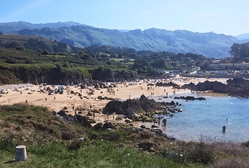
The highlight of the trip is As Catedrais beach (Augas Santas), with rock arches that recall the flying buttresses of a Gothic cathedral. At Easter and from 1 July to 30 September you need a free permit (find out more from Ribadeo Tourism ↗). If you'd like it explained, there's a free 45-minute guided tour.
For sunset, the Senda Azul (Blue Path) follows 5.6 km of easy coastline to Illa Pancha and its two lighthouses.
On the road » About 20 km to Barreiros on the LU-P-5203 and the N-634.
13. Barreiros
Barreiros calls itself “un mar de praias” (a sea of beaches): nine beaches along more than 8 km of coast. Arealonga borders As Catedrais and hosts an international sandcastle competition every 25 July. Coto has almost 2 km of white sand and restored dunes, and on one of its rocks lies a medieval seaside tomb that is unique of its kind. Lóngara and Fontela are for surfing, and at Altar, already inside the estuary, you can walk out to Pena de Altar at low tide.
As you stroll, look in the sand for a bítere: an oval piece, white on one side and orange on the other. According to local tradition, whoever finds one is assured a year of love and luck.
On the road » About 15 km on the N-642 to Foz, crossing the estuary.
14. Foz
The route ends by the Foz-Masma estuary, a protected haven for birds that stretches as far as A Rapadoira beach, the town beach. The treasure lies less than 5 km from the centre: the Basilica of San Martiño de Mondoñedo (11th-12th c., free entry), which Lugo's provincial council presents as the oldest cathedral in Spain, with Romanesque murals and capitals depicting scenes such as the Last Supper.
San Martiño was the seat of the ancient bishopric of Britonia and is now gathering support for its bid to become a World Heritage Site.
Where to sleep on the route: the 14 TripStop camper spots
Every stop on this route has a camper spot on TripStop. Here are all 14, in travel order:
🚐 1. Bermeo: Área Bermeo
🚐 2. Zierbena: La Arena Camper Park
🚐 3. Guriezo: Bidaivan Camper Park
🚐 4. Santoña: El Paraíso de Berria
🚐 5. Santa Cruz de Bezana: Área Camper Bezana
🚐 6. Cóbreces: Área Las Hazas
🚐 7. Comillas: Cogiendo Aire – Comillas Camper Park
🚐 8. Ribadedeva: Tinamayor Camper Park
🚐 9. Llanes: Área de Llanes
🚐 10. Gijón: Camper Park Gijón
🚐 11. Tapia de Casariego: Área Tapia de Casariego
🚐 12. Covelas (Ribadeo): Área Granja Casecha
🚐 13. Barreiros: Coto Camper
🚐 14. Foz: Atalaia Camper Park
📲 Check availability and book your pitch in the TripStop app before you arrive.
Conclusion
From the cliffs of Bermeo to the Foz estuary, this motorhome route through northern Spain brings together the best of the Cantabrian coast in fourteen stops: fishing ports, lighthouses, beaches that change with the tide, indiano towns and works by Gaudí and Chillida. Take your time, book the two must-see visits in advance and let the sea set the pace.
And to sleep easy at every stage, each stop has its own camper spot on TripStop.